
Kiribati Weather, climate and geography
Weather & climate
Maritime equatorial in the central islands of the group. The islands to the north and south are more tropical. The trade winds blow between March and October, making this the most pleasant time of the year, while the highest rainfall (December to May) is concentrated on the northern islands. November to February is more wet and humid than the rest of the year.
Geography
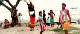
Kiribati (pronounced 'Kiribass', formerly the Gilbert Islands) consists of three groups in the central Pacific: Kiribati (including Banaba, formerly Ocean Island), the Line Islands and the Phoenix Islands. The 33 islands, scattered across 5 million sq km (2 million sq miles) of the central Pacific, are low-lying coral atolls with coastal lagoons. The exception is Banaba, which is a coral formation rising to 80m (265ft). The soil is generally poor, apart from Banaba, and rainfall is variable. Coconut palms and pandanus trees comprise the main vegetation. There are no hills or streams throughout the group. Water is obtained from storage tanks or wells.
Do you have any Feedback about this page?
© 2026 Columbus Travel Media Ltd. All rights reserved. No part of this site may be reproduced without our written permission, click here for information on Columbus Content Solutions.


 You know where