
Pakistan Weather, climate and geography
Weather & climate
The northern regions, including Gilgit-Baltistan and Khyber Pakhtunkhwa, experience long and harsh winters with heavy snowfall and freezing temperatures, particularly in the mountainous areas. Summers (June to August), however, are mild and pleasant, with temperatures typically ranging between 15°C to 25°C (59°F to 77°F), making it an ideal time for trekking, exploring valleys like Hunza and Swat, and enjoying the serene beauty of the Karakoram Range. Winter is perfect for skiing enthusiasts heading to Malam Jabba or other snow-laden destinations.
In the central plains of Punjab and Islamabad, summers (April to June) can be extremely hot, with temperatures frequently exceeding 40°C (104°F). July and August are technically part of the monsoon season – temperatures decrease slightly, but the added humidity can be uncomfortable. Spring (March to April) and autumn (October to November) offer the most pleasant weather. Cities like Lahore and Islamabad are best visited during these transitional seasons when the heat has subsided and the surroundings are lush and vibrant.
The southern region of Sindh, including Karachi, has a hot desert climate, where summers can be scorching, with inland temperatures soaring above 45°C (113°F). Coastal areas, while cooler, are humid. Winters (November to February) in this region are mild, ranging from 15°C to 25°C (59°F to 77°F), making it the best time to explore Karachi's vibrant cityscape, the historic sites of Thatta, and the vast stretches of the Thar Desert.
The western province of Balochistan is characterised by its arid desert climate and stark temperature variations. Summers (May to September) are hot, with peak heat occurring in June and July. Temperatures in places like Sibi can soar above 45°C (113°F). In contrast, winters (December and February) are cold, but the snow-covered landscapes in Ziarat make it a worthwhile destination.
Wear lightweight clothing suitable for warm weather, but pack warmer items like base layers and woollens if you plan to visit upland areas during winter. Good trekking boots, walking poles, and thermal wear are essential for mountain explorers. While woollen socks and sweaters can be purchased at reasonable prices in Pakistani bazaars, they may be heavier and not up to Western quality standards.
During the monsoon season (July to August), rainwear is essential as torrential downpours can lead to significant flooding in cities. For these conditions, wellington boots might also be practical.
Consider buying a shalwar kameez (the traditional tunic and baggy trousers) after arriving in Pakistan. This outfit is practical for both men and women, especially in the heat. In intense summer temperatures, covering up with cool, loose-fitting cotton, such as those worn by locals, is far more comfortable and culturally appropriate than wearing revealing clothing. This helps protect against the sun while avoiding unnecessary attention.
Geography
Pakistan is strategically located in South Asia, sharing borders with four countries. To the east lies India, with a 3,323 km (2,065-mile) border marked by the Wagah crossing and the contentious Line of Control in Kashmir. The Durand Line separates Pakistan from Afghanistan to the northwest, spanning 2,670 km (1,659 miles). To the west, a 959 km (596-mile) border connects Pakistan with Iran, while to the northeast, the Khunjerab Pass links the country to China along a 438 km (272-mile) frontier. This unique geographic position makes Pakistan a crossroads of South Asia, Central Asia, and the Middle East, offering travellers access to an incredible diversity of landscapes and cultures.
The northern region of Pakistan is home to some of the world's tallest peaks, including K2 (the second-highest mountain on Earth) in the Karakoram Range, and vast plateaus, such as the rugged Balochistan Plateau. The north is also renowned for lush valleys like Hunza, Swat, and Kaghan, as well as high-altitude lakes, glaciers, and breathtaking trekking routes.
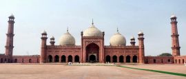
Central Pakistan is dominated by the fertile plains of the Indus River, often referred to as the lifeline of the country. This area, including Punjab and Sindh, is a cultural and agricultural heartland dotted with ancient cities like Multan, Lahore, and Mohenjo-Daro. Travellers can explore vast green fields, bustling towns, and iconic heritage sites that tell the story of Pakistan's history and civilisation.
To the south, Pakistan's coastline stretches along the Arabian Sea, offering pristine beaches in Karachi and the more remote Gwadar. The southwestern region is also home to the Thar Desert, a dramatic expanse of sand dunes and arid beauty, where visitors can experience traditional desert lifestyles. Together, the coastline and deserts showcase the contrasts and unique ecosystems that make Pakistan’s geography so compelling.
Do you have any Feedback about this page?
© 2026 Columbus Travel Media Ltd. All rights reserved. No part of this site may be reproduced without our written permission, click here for information on Columbus Content Solutions.


 You know where