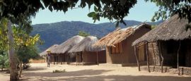
Malawi Weather, climate and geography
Weather & climate
Varies from cool in the highlands to warm around Lake Malawi. Winter (May to July) is dry and nights can be chilly, particularly in the highlands. The rainy season runs from November to March. Around Lake Malawi, in winter, the climate is particularly dry with pleasant cooling breezes.
Lightweights are worn all year in the Lake Malawi area, with warmer
clothes advised in the mountains, particularly during winter and on
chilly evenings elsewhere. Visitors to Nyika and Zomba should note that
the nights can be cold. Dark or 'natural' coloured clothing should be
worn for game viewing.
Geography
Malawi shares borders to the north and northeast with Tanzania, to the south, east and southwest with Mozambique and to the west with Zambia. Lake Malawi, the third largest lake in Africa, is the dominant feature of the country, forming the eastern boundary with Tanzania and Mozambique. The scenery varies in the country's three regions. The Northern Region is mountainous, with the highest peaks reaching over 2,500m (8,200ft), and features the rolling Nyika Plateau, rugged escarpments, valleys and the thickly forested slopes of the Viphya Plateau. The Central Region is mainly a plateau, over 1,000m (3,300ft) high, with fine upland scenery. This is the country's main agricultural area. The Southern Region is mostly low-lying except for the 2,100m-high (6,890ft) Zomba Plateau south of Lake Malawi and the huge, isolated Mulanje Massif (3,000m/10,000ft) in the southeast. The variety of landscape and the wildlife it supports make this relatively unspoilt country particularly attractive to visitors.
Do you have any Feedback about this page?
© 2026 Columbus Travel Media Ltd. All rights reserved. No part of this site may be reproduced without our written permission, click here for information on Columbus Content Solutions.


 You know where