
Cambodia Weather, climate and geography
Weather & climate
Cambodia has a tropical climate with warm temperatures throughout the year and distinct dry and wet seasons. The dry season runs from November to April and is generally the most popular time to visit. During this period, daytime temperatures typically range from around 25°C to 32°C (77°F to 90°F), with lower humidity and little rainfall, making conditions more comfortable for sightseeing and travel.
The hottest months are March and April, when temperatures can rise to around 35°C or higher (95°F or above), particularly in inland areas. The wet season usually lasts from May to October and is characterised by short but heavy afternoon downpours rather than continuous rain. Temperatures during the wet season remain warm, generally between 24°C and 30°C (75°F to 86°F), and the countryside becomes lush and green.
Spring in Cambodia broadly covers March to May, a period marked by rising heat and the transition from dry to wet conditions. While rain becomes more frequent from May onwards, travel remains possible year-round, with fewer visitors and lower prices during the wetter months.
Lightweight, breathable clothing is recommended throughout the year due to Cambodia’s warm and humid climate. Natural fabrics such as cotton and linen are most comfortable. A light jumper or jacket may be useful for air-conditioned buses, flights or hotels, but heavy clothing is rarely needed.
Modest dress is important, particularly when visiting temples and rural areas. Both men and women should cover their shoulders and knees at religious sites, and a light scarf or shawl can be useful. During the rainy season, from May to October, visitors are advised to carry rain protection such as a light rain jacket, poncho or umbrella, as showers can be heavy but brief. Comfortable, water-resistant footwear is also useful during this period.
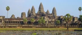
Geography
Cambodia is located in mainland Southeast Asia and is bordered by Thailand to the west and north-west, Laos to the north, Vietnam to the east and south-east, and the Gulf of Thailand to the south. The country is largely low-lying, with much of its landscape shaped by rivers, floodplains and fertile agricultural land. This geography has long supported rice cultivation, which remains central to both the economy and daily life.
The Mekong River is Cambodia's most important geographic feature, flowing from north to south through the eastern part of the country before continuing into Vietnam. Connected to it is the Tonle Sap Lake, Southeast Asia's largest freshwater lake, which plays a crucial role in fishing, agriculture and flood control. Uniquely, the Tonle Sap River changes direction seasonally, expanding the lake dramatically during the rainy season and supporting one of the region's richest ecosystems.
Away from the central plains, Cambodia is ringed by upland and mountainous areas. The Cardamom Mountains and Elephant Mountains rise in the south-west, while the Dangrek Mountains form part of the northern border with Thailand. These regions are less densely populated and covered by forests, national parks and protected areas. Cambodia's coastline, though relatively short, includes sandy beaches, mangroves and offshore islands along the Gulf of Thailand, adding further geographic variety to the country.
Do you have any Feedback about this page?
© 2026 Columbus Travel Media Ltd. All rights reserved. No part of this site may be reproduced without our written permission, click here for information on Columbus Content Solutions.


 You know where