
Northern Territory Weather, climate and geography
Weather & climate
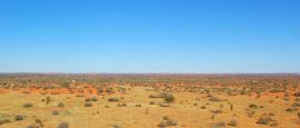
Covers 1,349,129 square kilometres (520,902 square miles), the Northern Territory has two distinct climates – tropical and rainforest in the northern half and semi-arid desert in the southern half.
Darwin, the capital, sits by the Timor Sea and experiences a tropical climate with average highs staying pretty consistent from 29°C (84°F) to 32°C (90°F) year-round. It has two distinct wet and dry seasons.
• The wet season in Darwin: October to April is the wet season with majority of the rainfall occurs between December and March - it is safe to expect 18 to 22 rainy days a month during this period. In January, the average high is 31°C (88°F) and the average low is 26°C (79°F), while the average rainfall is 420mm (17 inches), making January the wettest month.
• The dry season in Darwin: May to September is the dry season – as Darwin sizzles in sunshine, this is the best time to visit Darwin. In July, the average high is 29°C (84°F) and the average low is 22°C (72°F), while the average rainfall is just 10mm (0.4 inches).
Located just south of the Tropic of Capricorn, Alice Springs has a desert climate with temperatures vary widely. Although the annual average high is 29°C (84°F), temperatures over 44°C (111°F) have been frequently recorded from October to February. The best time to visit Alice Springs is from June to August when average highs dip to 21°C (70°F) – but bring a jacket as night time temperatures can fall below freezing. Rainfall, despite little, mostly occurs between November and March.
Geography
A wilderness stretching roughly 1,670km (1,038 miles) from Darwin and Kakadu in the north to Uluru (Ayers Rock) in the south and 1,000km (620 miles) east to west, the Northern Territory comprises nearly one-sixth of Australian mainland. It is roughly the size of France, Spain and Italy combined.
Due to its size, it is common to hear people use the phrases ‘Top End’ and ‘Red Centre’ when referring to a chunk of geographical region within the Territory. Here is a summary:
The Top End: The Top End is referred to the geographical area covering Darwin the capital of the Northern Territory, UNESCO-listed Kakadu National Park, Arnhem Land (an area of vast flood plains and rocky escarpments steeped in natural and cultural heritage, as it is said that Aboriginal people have lived here for at least 35,000 years) and the Katherine area.
The Red Centre: The Red Centre is centred around Alice Springs, which is almost at the geographical centre of Australia and the starting point of many of the Red Centre's unique and natural wonders, including Uluru (Ayers Rock).
Do you have any Feedback about this page?
© 2026 Columbus Travel Media Ltd. All rights reserved. No part of this site may be reproduced without our written permission, click here for information on Columbus Content Solutions.


 You know where