
Puerto Rico Weather, climate and geography
Weather & climate
Unlike many islands in the Caribbean, any time is really the best time to visit Puerto Rico and enjoy its tropical climate. The rainy season is from April to November, but precipitation patterns and amounts vary considerably from one part of the island to the other. Even in the rainiest areas, showers are likely to be intense but brief.
If you're travelling from San Juan to Ponce (or vice-versa), you'll notice an immediate difference once you reach the top of the mountain about halfway through your journey. The south tends to be drier than the north. In the mountainous region, you'll want a light jacket or sweater, as the higher elevation means cooler temperatures.
1 June to 30 November is hurricane season, though Puerto Rico is rarely affected by hurricanes. February is an excellent time to visit Puerto Rico; when temperatures are typically cold on the mainland USA, they're usually neither too hot nor too cool in la isla del encanto, the island of enchantment.
Lightweight tropical clothes. Light rainwear required. Dress clothes for finer dining and nightclub visits. Bathing suits, of course, are de rigeur for those who plan to enjoy the water! A hat and sunglasses will help protect you from the sun's searing rays, and if you plan to snorkel or spend lots of time in the water, a long-sleeved shirt that repels UV rays is highly recommended.
Geography
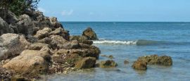
Puerto Rico is an island east of the Dominican Republic and west of the British Virgin Islands. The rougher, cooler Atlantic Ocean is on the north side of the island; the calmer, warmer Caribbean Sea is on the south side. It is the smallest island in the Greater Antilles and the largest island in the Lesser Antilles. Culebra, Mona and Vieques are among several smaller islands that are part of Puerto Rican territory. The waters surrounding the island are quite deep; the Puerto Rico trench is the deepest part of the Atlantic Ocean.
The island is comparatively small, 8,959 sq km (3,459 sq miles), with a central mountain range reaching an altitude of 1,338m (4,390ft) at Cerro de Punta, and surrounded by low coastal plains. The island has remarkable geographic diversity for its size, with limestone formations in the interior, a desert in the southeastern part of the island, and the rainforest. Mangroves dominate the southern shore and are an important part of the island's ecosystem.
San Juan, the capital, is on the northeast shore. Much of the island's natural forest has been cleared for agriculture, but the trees in the northeast corridor are protected as a national park. One of the hot-button environmental and political issues on the island is increasing development, particularly by the tourism industry with respect to hotel and resort construction. The island's nature conservancy, the Fideicomiso, has played a critical role in acquiring and protecting significant land and restoring properties for public visits and educational purposes.
The other main towns are Aguadilla, Arecibo, Bayamón, Caguas, Carolina, Cayey, Fajardo, Guaynabo, Mayagüez and Ponce.
Do you have any Feedback about this page?
© 2026 Columbus Travel Media Ltd. All rights reserved. No part of this site may be reproduced without our written permission, click here for information on Columbus Content Solutions.


 You know where