
Costa Rica Weather, climate and geography
Weather & climate
Costa Rica has a tropical climate, but weather conditions vary considerably between regions due to differences in altitude, coastline and exposure to prevailing winds. Broadly speaking, the country experiences a dry season from December to April and a rainy or "green" season from May to November, though the Caribbean coast follows a somewhat different pattern from the Pacific side. Temperatures remain relatively stable throughout the year, with altitude playing a greater role than season in determining climate.
Pacific coast
The Pacific coast has a pronounced dry season from December to April, when days are typically sunny, hot and humid with very little rainfall. This is generally considered the best time to visit beach destinations such as Tamarindo, Manuel Antonio, Santa Teresa and the Nicoya Peninsula. Daytime temperatures commonly range from 30 to 35°C (86 to 95°F) in lower coastal areas.
The rainy season on the Pacific side usually begins in May and intensifies between September and October. Rain often arrives in heavy afternoon downpours followed by clearer mornings, particularly earlier in the season. Despite the wetter conditions, the landscape becomes greener and less dusty, and there are generally fewer visitors outside major holiday periods.
Central Valley and Highlands
The Central Valley, including San José, enjoys a milder climate due to its altitude. Temperatures are generally comfortable throughout the year, typically ranging from 20 to 28°C (68 to 82°F) during the day with cooler evenings. Many visitors find the climate here more pleasant than the hotter coastal regions.
Mountain and cloud forest regions such as Monteverde and parts of the Cordillera de Talamanca are cooler, wetter and often misty, particularly during the rainy season. Temperatures at higher elevations can fall below 10°C (50°F) at night. Rainfall is possible year-round in cloud forest areas, even during the dry season.
Caribbean coast
The Caribbean coast has a more humid and less predictable climate than the Pacific side, with rainfall possible throughout the year. Puerto Viejo de Talamanca, Cahuita and Tortuguero are generally wetter than the Pacific coast, and short tropical downpours are common even during drier periods.
Unlike the Pacific coast, the Caribbean side often experiences some of its best weather in September and October, when rainfall may temporarily decrease and conditions become sunnier. Temperatures along the Caribbean coast usually range between 28 and 32°C (82 to 90°F) with high humidity throughout the year.
The best time to visit Costa Rica depends largely on the regions and activities planned. The dry season is generally preferred for beach holidays, wildlife viewing and easier road conditions, while the rainy season offers greener landscapes, fewer crowds and often lower prices.
Lightweight cotton or linen clothing is suitable for most of Costa Rica due to the tropical climate, particularly in coastal and lowland regions where conditions are hot and humid throughout the year. Breathable fabrics are strongly recommended, and visitors should be prepared for sudden tropical rain showers regardless of season.
For the Pacific and Caribbean coasts, lightweight summer clothing, swimwear, sandals and sun protection are essential. A wide-brimmed hat, sunglasses and high-factor sunscreen are advisable due to the strength of the tropical sun. Insect repellent is also important, especially in rainforests and coastal areas where mosquitoes are common.
The Central Valley and highland regions, including Monteverde and parts of the volcanic interior, are noticeably cooler, particularly in the evenings and early mornings. A light jumper, fleece or jacket is useful for higher elevations, while waterproof clothing is advisable in cloud forest regions where mist and rain are frequent.
Visitors travelling during the rainy season from May to November should carry a lightweight waterproof jacket or poncho and suitable footwear for muddy trails and wet conditions. Quick-drying clothing is often more practical than heavier fabrics.
For hiking, wildlife excursions and national parks, sturdy walking shoes or hiking boots are recommended. Some rainforest trails can become slippery after rain, particularly in more remote areas.
Casual dress is accepted in most situations, though smarter clothing may be appropriate for business meetings, higher-end restaurants and hotels in San José and resort areas.
Geography
Costa Rica is located in Central America, bordered by Nicaragua to the north, Panama to the southeast, the Pacific Ocean to the west and south, and the Caribbean Sea to the east. Despite covering a relatively small area, the country contains an extraordinary range of landscapes and ecosystems shaped by volcanic activity, mountain ranges, tropical climate zones and two distinct coastlines.
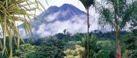
The country is dominated by a series of mountain chains running from northwest to southeast through the interior. These include the Cordillera de Guanacaste, Cordillera Central and Cordillera de Talamanca. Several of Costa Rica's volcanoes lie within these ranges, including Arenal, Poás and Irazú, the latter being the country's highest active volcano. Cerro Chirripó, in the Talamanca range, is the highest point in Costa Rica at 3,821 metres (12,536 ft).
The Central Valley, where the capital San José is located, lies between the country's principal mountain ranges and contains much of Costa Rica's population, agriculture and industry. The combination of altitude, fertile volcanic soils and milder temperatures has historically made the region the economic and political heart of the country.
To the east, the land descends into humid Caribbean lowlands covered by rainforest, rivers and wetlands. Tortuguero and the Caribbean coastal plain are characterised by dense tropical vegetation, canals and high rainfall. To the west, the Pacific side contains more geographical variation, ranging from dry tropical forest in Guanacaste to rainforest-covered peninsulas and rugged coastline in the south.
Costa Rica's biodiversity is among the richest in the world relative to its size. The country sits at the meeting point of North and South American ecosystems, allowing wildlife from both continents to coexist. Rainforest, cloud forest, mangroves, volcanoes, coral reefs and dry forest all occur within comparatively short distances of one another.
Do you have any Feedback about this page?
© 2026 Columbus Travel Media Ltd. All rights reserved. No part of this site may be reproduced without our written permission, click here for information on Columbus Content Solutions.


 You know where
