
Cook Islands Weather, climate and geography
Weather & climate
Weather can be quite changeable from day to day and varies throughout the islands. It is generally hot throughout the year, although the trade winds provide some moderating influence. Rainfall is heaviest in Rarotonga, while the northern atolls tend to be drier. The coolest months are June to August, while November to March marks the warmer season, which also has the highest rainfall.
Geography
The Cook Islands are situated 3,500km (2,200 miles) northeast of New Zealand and 1,000km (600 miles) southwest of Tahiti in the South Pacific, forming part of Polynesia. The 15 islands fall into two groups: the scattered Northern Group are all coral atolls while the Southern Group is of volcanic origin. Most of the larger islands include lagoons surrounded by small areas of fertile land above which rise volcanic hills.
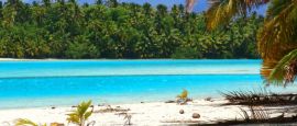
Rarotonga is the largest and highest island with a rugged volcanic interior, its highest peak being Te Manga, at 652m (2,140ft). Coral reef surrounds the island and the population lives between reef and hills where rich soil supports both tropical and subtropical vegetation. Most of the island is covered by thick evergreen bush. Most of the larger islands include lagoons surrounded by small areas of fertile land, above which rise volcanic hills. The best beaches in the Cook Islands are found on Aitutaki, which is part of the eight-island Southern Group. The Northern Group comprises seven islands, the largest being Penrhyn, Manihiki and Pukapuka.
Do you have any Feedback about this page?
© 2026 Columbus Travel Media Ltd. All rights reserved. No part of this site may be reproduced without our written permission, click here for information on Columbus Content Solutions.


 You know where